
According to the Cyclone Warning Division of the India Meteorological Department (IMD): (At 20.30 Hrs)
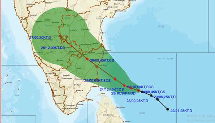
The cyclonic storm ‘NIVAR” over southwest Bay of Bengal moved westwards with a speed of 05 kmph during past six hours and lay centred at 1730 hrs IST of 24th November, 2020 over southwest Bay of Bengal about 320 km east-southeast of Cuddalore, about 350 km southeast of Puducherry and 410 km east southeast of Chennai. It is very likely to intensify further into a severe cyclonic storm during next 06 hours and into a very severe cyclonic storm during subsequent 12 hours.
Earlier, at a joint Press conference with the DG, NDRF in New Delhi, Dr. M. Mohapatra DG IMD informed that It is very likely to move west-northwestwards for next 06 hours and then northwestwards. It is very likely to cross Tamil Nadu and Puducherry coasts between Karaikal and Mamallapuram around Puducherry during 25th November 2020 late evening as a very severe cyclonic storm with a wind speed of 120-130 kmph gusting to 145 kmph, he said.
Forecast track and intensity are given below:
Date/Time(IST) |
Position (Lat. 0N/ long. 0E) |
Maximum sustained surface wind speed (Kmph) |
Category of cyclonic disturbance |
24.11.20/1730 |
10.0/82.4 |
85-95 gusting to 105 |
Cyclonic Storm |
24.11.20/2330 |
10.1/82.0 |
95-105 gusting to 115 |
Severe Cyclonic Storm |
25.11.20/0530 |
10.4/81.4 |
110-120 gusting to 135 |
Severe Cyclonic Storm |
25.11.20/1130 |
11.0/80.7 |
120-130 gusting to 145 |
Very Severe Cyclonic Storm |
25.11.20/1730 |
11.5/80.1 |
120-130 gusting to 145 |
Very Severe Cyclonic Storm |
26.11.20/0530 |
12.3/79.2 |
70-80 gusting to 90 |
Very Severe Cyclonic Storm |
26.11.20/1730 |
13.1/78.3 |
50-60 gusting to 70 |
Deep Depression |
27.11.20/0530 |
13.9/77.4 |
35-45 gusting to 55 |
Depression |
Warnings:
(i) Rainfall
Dr. Mohapatra said that fairly widespread to widespread rainfall/thunderstorm activity is very likely over coastal and north interior Tamilnadu, Puducherry & Karaikal during 24th to 26th November and over south coastal Andhra Pradesh, Rayalaseema during 25th to 26thand southeast Telangana during 26thNovember, 2020.Isolated extremely heavy rainfall activity also very likely over coastal & north interior Tamilnadu & Puducherry(Pudukottai, Thanjavur, Tiruvarur, Karaikal, Nagapattinam, Cuddalore, Chennai, Kanchipuram, Chengalpattu, Myladuthirai, Ariyalur & Perambalurdistricts during 24th and Kadalur, Kallakurchi, Puducherry, Villupuram, Tiruvannamalai, Myladuthirai, Chennai, Kanchipuram, Chengalpattu, Ariyalur, Perambalur and Karaikaldistricts during 25th; over Nellore and Chittoor districts of Andhra Pradeshon 25th and over Rayalseema & southeast Telangana on 26th November,2020.
| Sub-Divisions | 24 Nov 2020* | 25 Nov 2020* | 26 Nov 2020* | 27 Nov 2020* |
| South Coastal Andhra Pradesh | Rainfall at a few places with heavy rainfall at isolated places | Rainfall at most places with isolated heavy to very heavy and extremely heavy falls | Rainfall at most places with isolated heavy to very heavy and extremely heavy falls | Rainfall at many places |
| Coastal & North Interior Tamilnadu, Puducherry & Karaikal | Rainfall at most places with heavy to very heavy rainfall and extremely heavy falls at isolated places | Rainfall at most places with heavy to very heavy rainfall at a few places and extremely heavy falls at isolated places | Rainfall at many places with heavy rainfall at isolated places | Rainfall at many places |
| South Interior Karnataka | Rainfall at a few places | Rainfall at many places with heavy rainfall at isolated places | Rainfall at many places with heavy rainfall at isolated places | Rainfall at many places |
| Rayalaseema | Rainfall at many places with isolated heavy falls | Rainfall at most places with heavy to very heavy rainfall with extremely heavy falls at isolated places | Rainfall at most places with heavy to very heavy rainfall at a few places and extremely heavy falls at isolated places | Rainfall at many places |
| Telangana | Rainfall at isolated places | Rainfall at a few places | Rainfall at most places with heavy to very heavy rainfall and extremely heavy falls at isolated places over southeast Telangana | Rainfall at many places |
(ii) Wind warning
- Gale wind speed reaching 85-95 kmph gusting to 105 kmph is prevailing over Southwest Bay of Bengal.Dr. Mohapatra also informed that it would further increase becoming 110-120 kmph gusting to 135 kmph over the southwest Bay ofBengal from 25th November morning increasing to 120-130 kmph gusting to 145 kmph during noon to night of 25th November.
- Squally wind speed reaching 35-45 kmph gusting to 55 kmph is prevailing along & off Tamil Nadu, Puducherry and adjoining South Andhra Pradesh coast and over Gulf of Mannar. It will gradually increase and become gale wind speed reaching 65-75 kmph gusting to 85 kmph from morning of 25th November and 120-130 kmph gusting to 145 kmph along & off coastal districts of north Tamil Nadu and Puducherry (Nagapattinam, Karaikal, Myladuthurai, Cuddalore, Puducherry, Villupuram & Chengalpattu districts; 80-90 gusting to 100 kmph very likely over Tiruvarur, Kanchipuram, Chennai, Tiruvallur districts) during noon to night of 25th November, 2020.
- Gale wind speed reaching 65-75 kmph gusting to 85 kmph very likely over adjoining westcentral Bay of Bengal and along & off South Andhra Pradesh (Nellore & Chittoor districts), Gulf of Mannar and along and off south coastal districts of Tamil Nadu during forenoon to night of 25th November, 2020.
(iii) Sea condition
The IMD Director General cautioned that the Sea condition is high over Southwest Bay of Bengal and rough to very rough along & off Tamil Nadu, Puducherry, south Andhra Pradesh coasts and over Gulf of Mannar. He said, it would gradually become very highover the southwest Bay of Bengal from 24th November night and phenomenal over the same area from noon to night of 25th November.
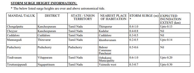
(iv) Strom Surge Warning
According to Dr. Mohapatra, tidal wave of about 1-1.5m height above the astronomical tide is very likely to inundate the low lying areas of north coastal districts of Tamilnadu & Puducherry near the place of landfall.
(v) (a)Damage expected over Nagapattinam, Myladuthurai, Cuddalore, , Villupuram & Chengalpattu districts of Tamilnadu and Karaikal & Puducherry:
Dr. Mohapatra also pointed out that in the wake of the cyclone, total destruction of thatched houses and extensive damage to kutcha houses might be expected. Some damage to old pucca houses, andpotential threat from flying objects, are also expected, he said. Among other expected damages, he pointed out the following:
- Bending/ uprooting of power and communication poles.
- Major damage to Kutcha and and Pucca roads. Flooding of escape routes. Disruption of railways, overhead powerlines and signalling systems.
- Widespread damage to standing crops, plantations, orchards, falling of green coconuts and tearing of palm fronds. Blowing down of bushy trees like mango.
- Small boats, country crafts may get detached from moorings.
- Visibility severely affected.
(v) (b)Damage expected over Tiruvarur, Kanchipuram, Chennai, Tiruvallaur districts of Tamilnadu and adjoining Andhra Pradesh:
- Damage to thatched houses/ huts with possibility of roof tops being blown off and unattached metal sheets may fly.
- Damage to power and communication lines.
- Damage to Kutcha and some damage to Pucca roads. Flooding of escape routes.
- Breaking of tree branches, uprooting of trees. Severe damage to banana and papaya trees, horticulture and crops & orchards. Large dead limbs blown from trees.
- Major damage to coastal crops. Damage to embankments/ salt pans.
(vi) Fishermen Warning & Action Suggested:
Dr. Mohapatra advised total suspension of fishing operations in the affected areas. He enumerated other measures like:
- Mobilise evacuation from coastal areas. Coastal hutment dwellers to be moved to safer places.
- People in affected areas to remain in safe places and indoors.
- Judicious regulation of rail, road and air traffic.
Movement in motor boats and small ships unsafe.
Storm Surge Guidance based on 1200 UTC observations of 24th November
Kindly download MAUSAM APP for location specific forecast & warning, MEGHDOOT APP for Agromet advisory and DAMINI APP for Lightning Warning.
click here to see pdf