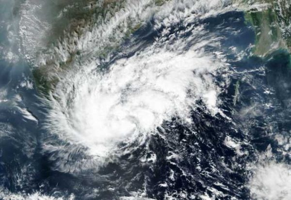
The Cyclone Warning Division of the India Meteorological Department (IMD) has come out with the preliminary report on very severe cyclonic storm “NIVAR” over Bay of Bengal during 22nd – 27th November, 2020.

Salient features of the report are discussed herewith:
A low pressure area formed over Equatorial Indian Ocean (EIO) and adjoining central parts of south BoB on 21st November. It concentrated into a depression over the same region in the early hours (0230 hrs IST) of 23rd November. Moving west-northwestwards, it intensified into a deep depression in the evening of 23rd and further into the cyclonic storm “NIVAR” in the early morning (0530 hrs IST) of 24th over southwest BoB. Thereafter, it intensified into a severe cyclonic storm in the midnight (2330 hrs IST) of 24th and into a very severe cyclonic storm in the afternoon (1430 hrs IST) of 25th.
Moving northwestwards, it crossed Tamilnadu & Puducherry coasts near Puducherry (near lat. 12.1°N and long. 79.9°E) during 2330 IST of 25th to 0230 IST of 26th as a very severe cyclonic storm with estimated wind speed of 120 kmph gusting to 135 kmph.
Moving across north Tamilnadu and coastal Andhra Pradesh, it weakened into a well marked low pressure area over south coastal Andhra Pradesh and adjoining westcentral BoB in the early morning (0530 hrs IST) of 27th November.
India Meteorological Department (IMD) maintained round the clock watch over the north Indian Ocean and the cyclone was monitored since 5th November, about 16 days prior to the formation of low pressure area over equatorial Indian Ocean and adjoining central parts of south BoB on 21st November and 18 days prior to the formation of depression over central parts of south BoB on 23rd.
The cyclone was monitored with the help of available satellite observations from INSAT 3D and 3DR, SCAT SAT, polar orbiting satellites and available ships & buoy observations in the region.
The system was also monitored by Doppler Weather RADARs (DWR) Chennai, Karaikal and Sriharikota.
Various numerical weather prediction models run by Ministry of Earth Sciences (MoES) institutions (IMD, IITM, NCMRWF, INCOIS), global models and dynamical-statistical models were utilized to predict the genesis, track, landfall and intensity of the cyclone.
A digitized forecasting system of IMD was utilized for analysis and comparison of various models’ guidance, decision making process and warning products generation.
The landfall point forecast errors for 24, 48 and 72 hrs lead period were 25, 25 and 16 km respectively against the LPA errors (2015-19) of 44.7, 69.4 and 109.3 km during 2015-19 respectively.
The track forecast errors for 24, 48 and 72 hrs lead period were 86.1, 126.8, and 185.0 km respectively against the LPA errors (2015-19) of 80.6, 125.5, and 171.2 km respectively.
The absolute error (AE) of intensity (wind) forecast for 24, 48 and 72 hrs lead period were 4.3, 6.5 and 10.2 knots against the LPA errors of 8.9, 13.0, and 15.4 knots during 2015-19 respectively.
IMD also issued regular advisories w.r.t. heavy rainfall and strong winds in association with the system.
A total of 38 bulletins to national level disaster managers & chief secretaries of Tamilnadu, Puducherry, Andhra Pradesh, Telangana, Andaman & Nicobar Islands, West Bengal, Odisha, Kerala and Lakshadweep.
In addition, 7 Nos. of press release, 6 bulletins from Director General of Meteorology to senior Government Officers, 13 bulletins for civil aviation, regular media briefings and joint press conference addressed by DGM IMD and DG NDRF on 24th.
The 3 hourly advisories were uploaded on all websites of IMD namely www.mausam.imd.gov.in and www.rscmcnewdelhi.imd.gov.in.
Warnings were also uploaded on all social networking sites including facebook, tweeter, whatsapp etc. frequently and sms were also sent to registered users on RSMC website, national level disaster managers and chief secretaries of concerned states.
Hourly bulletins were also issued 12 hours prior to landfall.
All the associated features including track, landfall, intensity and adverse weather like heavy rainfall and strong winds were accurately predicted with sufficient lead time by IMD, thus minimising loss of lives associated with the system.
The report is available on RSMC website under Publication Section and Mausam website under Cyclone Section at thelink:
http://www.rsmcnewdelhi.imd.gov.in/images/pdf/publications/preliminary-report/nivar20.pdf
Please Click here for the Detailed Report.
Kindly download MAUSAM APP for location specific forecast & warning, MEGHDOOT APP for Agromet advisory and DAMINI APP for Lightning Warning.

