The National Weather Forecasting Centre/Regional Meteorological Centre, New Delhi of the India Meteorological Department (IMD) has said:
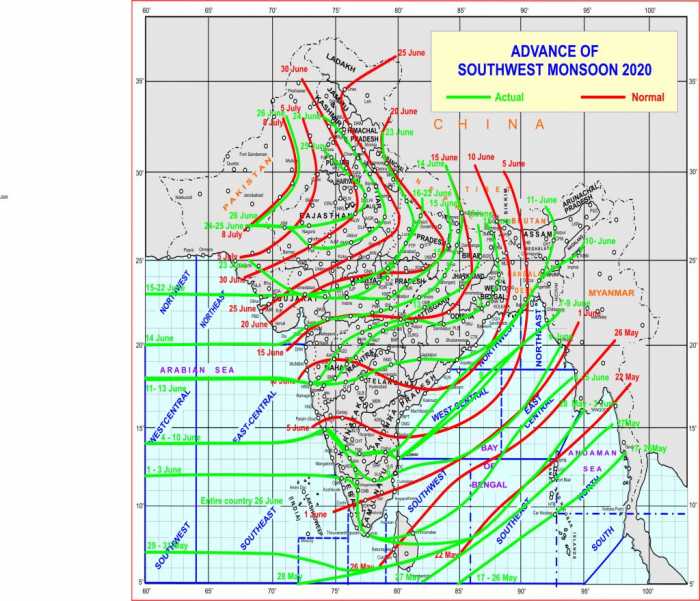
Southwest Monsoon covered entire country today, the 26th June 2020.
- The Southwest Monsoon has further advanced into remaining parts of Rajasthan,Haryana and Punjab and thus it has covered the entire country today, the 26th June 2020(Fig. 1).
- The normal date for Southwest Monsoon to cover entire country is 8th July. Therefore, theSouthwest Monsoon this year has covered the entire country 12 days prior to normaldate.
- In the recent past, such early coverage of Southwest Monsoon over the entire countryoccurred in 2013, The Southwest Monsoon covered the entire country on 16th Juneduring 2013.
- During past 24 hours, there has been fairly widespread rainfall activity over WestRajasthan and adjoining Punjab & Haryana in association with the cyclonic circulation at lower tropospheric levels over northeast Rajasthan.
- Considering southwest monsoon onset and advance over the country as a whole, there has been normal progress over south and east India, about a week delay advance over northeast India and about 7-12 days early advance over central & northwest India. The early advance over the central & northwest India was facilitated by formation of a low pressure area over Bay of Bengal which moved west-northwestwards and another cyclonic circulation over central India.
Meanwhile,
Update for ongoing intense southwest monsoon rainfall spell over northeast &
adjoining east India
Current Meteorological Conditions
- Eastern end of the monsoon trough at mean sea level lies close to foothills of Himalayas.
- Another trough runs from Bihar to east Vidarbha at 3.1 km above mean sea level. It is likely to perisists tilltomorrow.
- There is high convergence of strong moist southerlies/southwesterlies winds from the Bay of Bengal overnortheast & adjoining east India and same is likely to continue for next 2-3 days. .
Forecast & Warnings
- With the above favourable meteorological conditions, the enhanced rainfall/thundershowers activity ismost likely to continue over the northeastern states &adjojinig east India during 26th & 28th June withlight to moderate widespread rainfall over Bihar, Sub-Himalayan West Bengal & Sikkim, ArunachalPradesh, Assam, Meghalaya, Nagaland, Manipur, Mizoram & Tripura and decrease in spread &intensity thereafter.
- Heavy to very heavy rainfall at a few places with extremely heavy falls (≥ 20 cm) at isolated places verylikely over Sub-Himalayan West Bengal & Sikkim on 26th & 27th and isolated heavy to very heavy falls on28th June, 2020.
- Heavy to very heavy rainfall at isolated places with extremely heavy falls very likely over Assam &Meghalaya on 26th & 27th, isolated heavy to very heavy falls on 28th and isolated heavy falls on 29th June,2020.
- Heavy to very heavy rainfall at isolated places with extremely heavy falls very likely over Bihar on 26th &27th, isolated heavy to very heavy falls on 28th and isolated heavy falls on 29th June, 2020.
- Isolated heavy to very heavy falls is also very likely over Arunachal Pradesh on 26th & 27th and isolated heavy falls on 28th June, 2020.
